Somalia: Geography and Environment
Mike Kanare
Somalia: Geography & Environment
Somalia is 627,337 square kilometers in total land area. In this space 8,591,629 people live here. These people are spread out all over the country. In December to February there is a northeast monsoon and there are moderate temperatures in the north and it is very hot in the south. Between the months of May and October there is a southwest monsoon and it is very dry in the north and it is still hot in the south. Between the monsoons the people of Somalia deal with irregular rainfall and hot and humid periods. Rainfall is scarce in most of the country and mainly falls in the northern elevated and mountainous parts of the country, and some parts of the southwest.
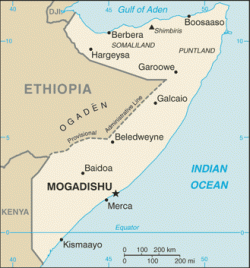
Somalia is bordered by Kenya, Ethiopia, and Djibouti to the west, by the Indian Ocean to the east, and by the Gulf of Aden to the north. The country’s coastline of 3,025 kilometers allows them to trade with the Middle East and the rest of East Africa efficiently. The country is mostly flat to the south but there are hills up in the northern part of the country.
Some natural hazards that happen in Somalia are recurring drought, dust storms in the summer, and floods during the rainy season. Some of the current environmental issues that are affecting Somalia in the present are; famine, contaminated drinking water that contributes to health problems, deforestation, soil erosion, and desertification. Most the country is desert to the south, but the desert is slowly expanding up towards the north.
Bibliography
"Geography and Map of Somalia."
Geography Home Page - Geography at About.com. 29 Apr. 2009 <http://geography.about.com/library/cia/blcsomalia.htm>.
"Somalia - GEOGRAPHY." Country Studies. 04 May 2009 <http://countrystudies.us/somalia/33.htm>.
Last updated May 22nd, 2009
